
Virginia topographic map
Interactive map
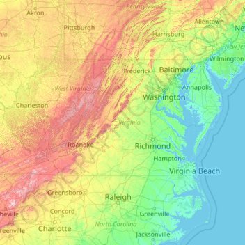
Click on the map to display elevation.
About this map
Name: Virginia topographic map, elevation, terrain.
Location: Virginia, United States (36.54079 -83.67537 39.46601 -75.16644)
Average elevation: 814 ft
Minimum elevation: -10 ft
Maximum elevation: 6,253 ft
Forests cover 62% of Virginia as of 2019, of which 78% is considered hardwood forest, meaning that trees in Virginia are primarily deciduous and broad-leaved. The other 22% is pine, with Loblolly and shortleaf pine dominating much of central and eastern Virginia. In the western and mountainous parts of the Commonwealth, oak and hickory are most common, while lower altitudes are more likely to have small but dense stands of moisture-loving hemlocks and mosses in abundance. Spongy moth infestations in oak trees and the blight in chestnut trees have decreased both of their numbers, leaving more room for hickory and invasive ailanthus trees. In the lowland tidewater and Piedmont, yellow pines tend to dominate, with bald cypress wetland forests in the Great Dismal and Nottoway swamps. Other common trees include red spruce, Atlantic White cedar, tulip-poplar, and the flowering dogwood, the state tree and flower, as well as willows, ashes, and laurels. Plants like milkweed, dandelions, daisies, ferns, and Virginia creeper, which is featured on the state flag, are also common. The Thompson Wildlife Area in Fauquier is known for one of the largest populations of trillium wildflowers in all of North America.
Other topographic maps
Click on a map to view its topography, its elevation and its terrain.
Kingwood
United States > Texas > Harris County > Houston
Kingwood, Houston, Harris County, Texas, 77345, United States
Average elevation: 72 ft
Houston
United States > Texas > Harris County
Houston, Harris County, Texas, United States
Average elevation: 82 ft
Seattle
United States > Washington > King County
Seattle, King County, Washington, United States
Average elevation: 131 ft
Dallas
United States > Texas > Dallas County
Dallas, Dallas County, Texas, United States
Average elevation: 525 ft
Austin
United States > Texas > Travis County
Austin, Travis County, Texas, United States
Average elevation: 709 ft
Conroe
United States > Texas > Montgomery County
Conroe, Montgomery County, Texas, United States
Average elevation: 203 ft
Denver
United States > Colorado > Denver County > Denver
Denver, Denver County, Colorado, United States
Average elevation: 5,525 ft
Atlanta
United States > Georgia > Fulton County
Atlanta, Fulton County, Georgia, United States
Average elevation: 932 ft
San Francisco
San Francisco, California, United States
Average elevation: 207 ft
San Diego
United States > California > San Diego County
San Diego, San Diego County, California, United States
Average elevation: 410 ft
Pittsburgh
United States > Pennsylvania > Allegheny County
Pittsburgh, Allegheny County, Pennsylvania, United States
Average elevation: 994 ft
Portland
United States > Oregon > Multnomah County
Portland, Multnomah County, Oregon, United States
Average elevation: 253 ft
Reno
United States > Nevada > Washoe County
Reno, Washoe County, Nevada, United States
Average elevation: 5,413 ft
Bend
United States > Oregon > Deschutes County
Bend, Deschutes County, Oregon, United States
Average elevation: 3,678 ft
Cypress
United States > Texas > Harris County
Cypress, Harris County, Texas, 77433, United States
Average elevation: 151 ft
San Antonio
United States > Texas > Bexar County
San Antonio, Bexar County, Texas, United States
Average elevation: 810 ft
Philadelphia
United States > Pennsylvania > Philadelphia County
Philadelphia, Pennsylvania, United States
Average elevation: 144 ft
Phoenix
United States > Arizona > Maricopa County
Phoenix, Maricopa County, Arizona, United States
Average elevation: 1,578 ft
Salt Lake City
United States > Utah > Salt Lake County
Salt Lake City, Salt Lake County, Utah, United States
Average elevation: 5,223 ft
Las Vegas
United States > Nevada > Clark County
Las Vegas, Clark County, Nevada, United States
Average elevation: 2,480 ft
Chicago
United States > Illinois > Cook County
Chicago, Cook County, Illinois, United States
Average elevation: 597 ft
Tucson
United States > Arizona > Pima County
Tucson, Pima County, Arizona, United States
Average elevation: 2,697 ft
Lake Tahoe
United States > California > Placer County
Lake Tahoe, Placer County, California, United States
Average elevation: 6,814 ft
Salem
United States > Oregon > Marion County
Salem, Marion County, Oregon, United States
Average elevation: 315 ft
Eugene
United States > Oregon > Lane County
Eugene, Lane County, Oregon, United States
Average elevation: 535 ft
New Orleans
United States > Louisiana > Orleans Parish
New Orleans, Orleans Parish, Louisiana, United States
Average elevation: 3 ft
City of Ithaca
United States > New York > Tompkins County
City of Ithaca, Tompkins County, New York, United States
Average elevation: 640 ft
Savannah
United States > Georgia > Chatham County
Savannah, Chatham County, Georgia, United States
Average elevation: 13 ft
Little Rock
United States > Arkansas > Pulaski County
Little Rock, Pulaski County, Arkansas, United States
Average elevation: 315 ft
Westchester County
Westchester County, New York, United States
Average elevation: 312 ft
Boston
United States > Massachusetts > Suffolk County
Boston, Suffolk County, Massachusetts, United States
Average elevation: 82 ft
Cleveland
United States > Ohio > Cuyahoga County
Cleveland, Cuyahoga County, Ohio, United States
Average elevation: 705 ft